
Do Not Build Below This Point: Japan’s Tsunami Stones
How communities on one coast tried to carry a warning across spans of time longer than memory itself, by writing it into stone, and what it takes to keep such a warning legible.

The Geography of Survival in Japan, Part 1
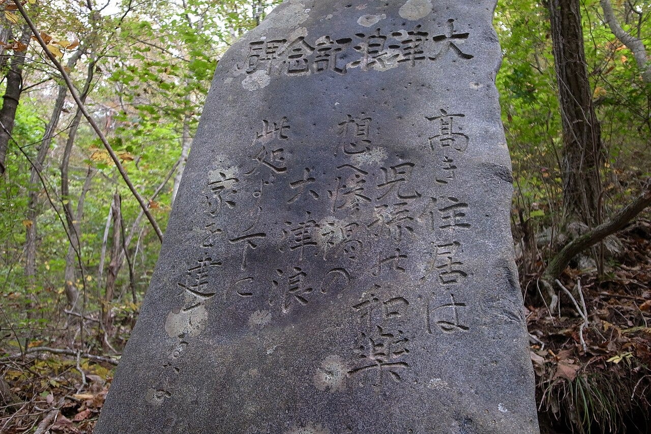
On a hillside above Aneyoshi, a small fishing settlement on the Sanriku coast of northeastern Japan, there stands a gray stone with a stark instruction carved into it: remember the great tsunamis, and do not build homes below this point.
The stone is not ancient. It was raised in the aftermath of the Showa Sanriku tsunami of 1933, by people who had just seen how far the sea could climb. Its power lies precisely there. This was not myth, nor metaphor, nor distant legend. It was local evidence, turned into a rule for generations not yet born.
For decades the stone simply stood, its warning untested by the people who passed it on their way to the boats. Then, in March 2011, after one of the most powerful earthquakes ever recorded struck off northeastern Japan, tsunami waves reached the Tohoku coast. In some places the sea first drew back; in others the water arrived as a fast-rising flood. Where it climbed the valley at Aneyoshi, it rose far up the slope and stopped short of the stone. The houses that had been kept above the marker were spared from tsunami damage. The marker had not predicted the future. It had preserved the measured experience of the past, and that was enough.
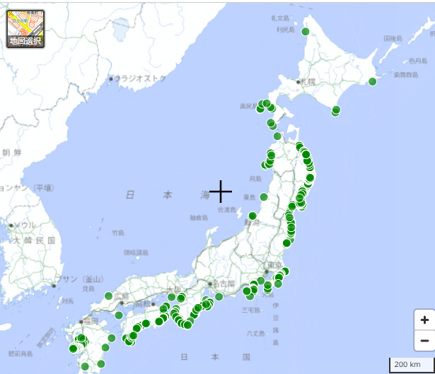
The stone at Aneyoshi is one page in a wider coastal archive. Along the Pacific side of Tohoku, the northern third of Japan’s main island, communities raised many tsunami stones after repeated disasters. They are not relics of superstition. They are local disaster data made durable, set down at the point where memory had to become geography, because on this coast the interval between great tsunamis can be longer than a human life.
This is the story of those stones, and of the geography that made them necessary.
Clue 1: Why This Coast Remembers
A hazard that returns more slowly than people can remember cannot be met by memory alone. It has to be met by something that outlasts the people who remember.
Begin with why this coastline has needed such warnings for so long. One detail of scale matters first. Aneyoshi is not a town but a tiny hamlet, small enough that a single rule about where to build could shape the fate of the whole community.
The northeastern coast of Japan faces the open Pacific. Offshore, in deep water, lies the Japan Trench, where the Pacific Plate grinds slowly beneath the overriding plate off northeastern Honshu. The two do not slide smoothly. They lock, strain builds over decades and centuries, and when the locked zone finally fails, the seafloor lurches and lifts the ocean above it. That displaced water spreads outward as a tsunami. Because this boundary sits directly off Tohoku, the coast has been struck again and again across recorded history.
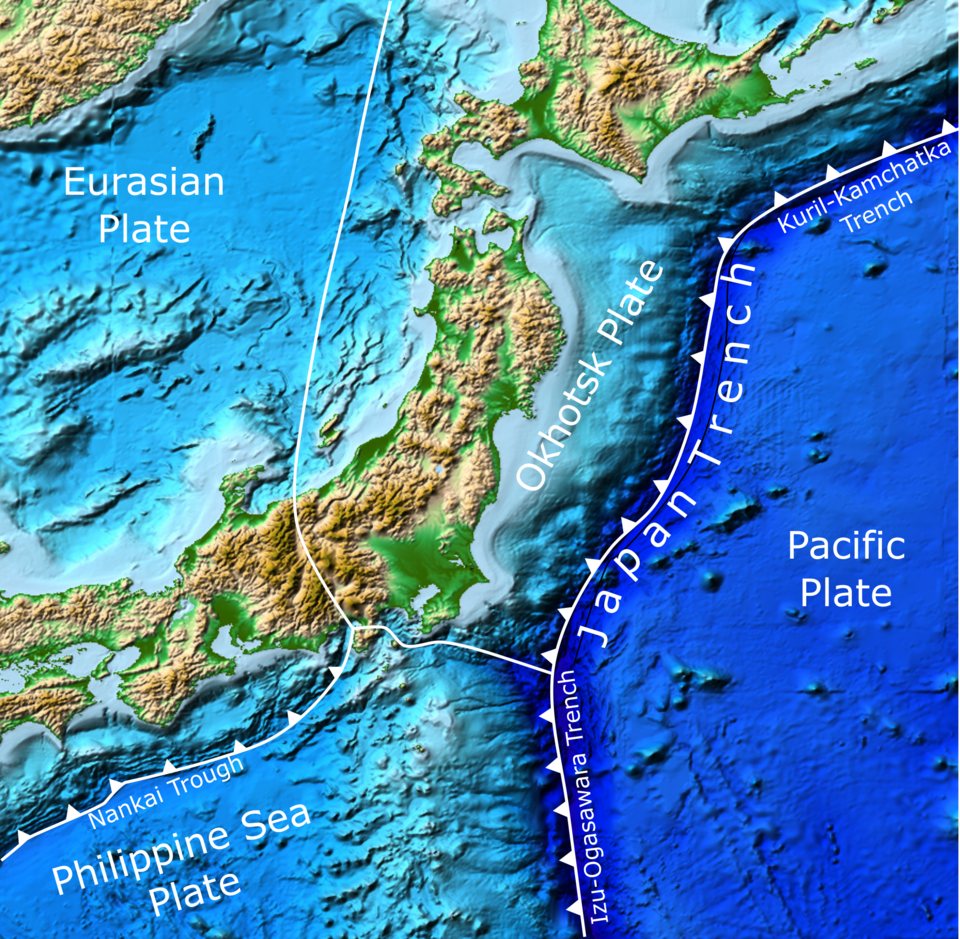
The shape of the coast then does something cruel to that water. Much of the Sanriku coast is a ria coastline: a land of river valleys drowned when the sea rose, leaving deep, narrow, V-shaped inlets reaching inland. Unlike the glacial fjords they are sometimes mistaken for, these inlets were carved mainly by rivers, then flooded by rising seas. They make superb natural harbors, sheltered and deep, which is exactly why people settled in them. But when a tsunami enters one, the water has little room to spread sideways. As the inlet narrows toward its head, the wave has one direction left, and it climbs. The same drowned valleys that make this coast beautiful and livable can also concentrate a wave’s energy and drive it upward, though how much depends on the shape of each inlet and is not uniform. Near Aneyoshi, the 2011 survey teams measured a run-up of around 39 meters, among the highest ever recorded in Japan, though the exact figure varies between studies.
This is not a uniquely Japanese predicament; it is a human one, and we will return to it. But this coast states the problem with unusual clarity, because the great tsunamis here are not freak accidents. They recur, on a rhythm measured not in years but in generations. The record carries great events in 1611, 1896, and 1933, and then 2011, with intervals stretching from a few decades to several centuries. An older disaster, the Jogan tsunami of 869, also belongs to the broader Pacific coast of Tohoku, but its evidence sits farther south, in a different landscape and a different form, and we will come to it.
That interval is the whole problem. A great tsunami may come once in a person’s lifetime, or never. A grandparent may warn of a disaster their grandchildren never see, and so the warning thins into a family story, then into rumor, then into nothing. By the time the sea returns, those who remember the last time are gone, and those in danger have never watched the water rise. The threat recurs more slowly than memory can hold it. That gap, between how often the sea returns and how long a warning survives in the mind, is the gap the stones were built to bridge.
Clue 2: How to Read a Tsunami Stone
Knowledge that must cross centuries cannot depend on understanding. It has to be compressed into an instruction simple enough that a stranger, generations later, can obey it without knowing why.
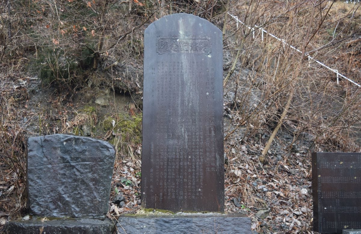
Tsunami stones are not a single designed system. They are a tradition that accumulated, community by community, as different villages marked different disasters and warned whoever would follow. Many such markers stand along Tohoku’s Pacific coast, dozens to hundreds depending on how they are counted. The Aneyoshi stone dates to the 1930s, but some are far older, raised after disasters centuries in the past, their inscriptions worn nearly smooth.
Read across them, and the messages fall into three kinds. Some are records, marking with a line and a date how far the water came. Some are memorials, honoring those who were lost and, in grieving, reminding the living that the danger was real. And a few give direct instructions to the future: flee uphill when the ground shakes, do not turn back for belongings, do not build below this line. The Aneyoshi stone is of this last kind, and unusual even among them in naming exactly where a house may safely stand.
What makes these instructions remarkable is how accurately they encode correct behavior. The advice to flee to high ground the moment the earth shakes captures the most immediate natural warning of a local tsunami, since strong, long ground shaking is often the first sign the coast gives before the water arrives. The instruction not to build below a marked line rests on hard evidence: the measured reach of past waves. The warning not to return for possessions addresses the specific hesitation that has cost the most lives. None of this is superstition. These are distilled, field-tested survival rules. A villager did not need to understand plate tectonics or wave dynamics. They needed only to read the stone and obey it. In modern terms, stones like Aneyoshi’s can function as data points: observations of extreme events, archived in the only medium that could survive long enough to matter. Taken together, the recording stones form something close to a pre-instrumental dataset, a record of extreme waves captured before seismographs or tide gauges existed.
That rule had one important limit. Fleeing after the shaking works best for a local tsunami, where the earthquake itself is the first warning. It does not work the same way for a distant one. In 1960, waves from an earthquake off Chile crossed the Pacific and reached this coast with no local shaking to announce them. That experience added a modern layer to the old lesson: natural signs matter, but they have to be joined to warning systems, maps, and public communication, because not every wave sends a tremor ahead of it.
There is a limit too. A stone can survive and still become unreadable. Its letters weather, its archaic language ages out of common use, and newcomers may not know why it stands where it does. Keeping a warning alive therefore takes translation as well as preservation. Mapped together, the markers become more than the sum of their parts: a distributed memory system written along a coastline, with no central author. It emerged stone by stone, disaster by disaster, as the accumulated answer of coastal communities learning to live beside a dangerous sea. This is less a grand civilizational project than a decentralized archive of survival, built village by village.
Clue 3: Why Warnings Fade
The weakest link in survival is not knowledge but memory, and every society that faces a rare catastrophe loses ground in the race between the two.
If the stones carried such clear warnings, a hard question follows: why, in 2011, was so much still lost?
The answer is not that people were foolish. It is that remembering, across the long quiet between disasters, is genuinely difficult, and three forces wear the warnings down.
The first is the erosion of memory by time. A warning is vivid while those who survived are alive to tell it in their own voices; after a few generations the last witnesses die, the telling becomes secondhand and then thirdhand, and decades of calm seas, generous and ordinary, quietly outweigh the abstract memory of a catastrophe no one living has seen. The words on the stone outlast the reason anyone remembers for them.
The second is the pressure of the land itself. On a coast of steep mountains and narrow inlets, flat ground near the water is scarce and valuable. It is where boats are kept, where the catch is landed, where daily life is convenient. That pull is constant, while the memory of the danger grows faint, and slowly, building by building, life creeps back below the old lines.
The third is the comfort of engineering. Modern sea walls can offer a sense of protection that a weathered stone never claimed to give. When concrete seems to promise safety, an old marker’s warning can look like a relic from a more fearful age.
This is not a Japanese problem but a human one. Every society that lives with rare disaster faces the same difficulty: the flood that comes once a century, the earthquake that comes once in five generations. These are the hazards hardest to keep alive in memory, precisely because the rhythm of the threat is slower than the rhythm of forgetting. Floodplains fill with houses again. Slopes below volcanoes are settled again. The half-life of a warning is shorter than the interval between the events it warns of.
The stones were a response to that universal problem, made in an unusually durable medium. Paper burns and rots. Spoken stories drift and thin with each retelling. Stone remains after the last storyteller is gone. The choice of medium was itself a piece of wisdom: memory needed an anchor more permanent than the human mind, so these communities wrote in the most lasting material they had and set it where it could not be avoided, in the path between the sea and the homes of the future. The stones did not solve the problem of forgetting. They slowed it down.
Clue 4: From Stone to Sediment: Two Archives of Tsunami Memory
When memory cannot be trusted to people, a society can try to store it elsewhere, in stone, or in the ground itself, where it no longer depends on anyone choosing to remember.
On this coast, long memory takes two forms. One archive is visible, carved by human hands. The other is invisible, buried by time. They record the same underlying danger, but they are not the same thing, and merging them is a mistake.
To keep the geography straight: Aneyoshi lies on the steep Sanriku ria coast in the north; the Sendai Plain lies farther south, a flat lowland where tsunami sediments settle and survive. That difference in terrain is why the two coasts remember in two different ways.
Around the Sendai Plain, the record of disaster is written not on the surface but beneath it. When the great Jogan tsunami struck in 869, it laid down a sheet of sand across the plain. Centuries of mud buried it, and it waited. Beginning in the 1990s, researchers excavating the plain identified that buried layer and reconstructed how far the ancient water had reached, carrying a warning that the next great tsunami could be far larger than recent experience suggested. When the 2011 water flooded the Sendai Plain, its inland limit turned out to be broadly comparable to the reconstructed reach of the Jogan tsunami, though researchers stress that differences in the landscape across eleven centuries make any direct comparison difficult.
This is a genuinely different kind of memory from the stones. The sediment record works on flat plains like Sendai’s, where tsunami sand can settle and survive. It barely exists along the steep ria coast where Aneyoshi sits, because such slopes do not hold deposits well. So the two coasts remember in two different ways: the southern plains in layers of earth read by scientists, the northern inlets in stone read by villagers. The Jogan layer is not what the Aneyoshi stone records. They are separate witnesses to the same fact, that on this coast, rare and enormous tsunamis return.
The land remembers in a fainter form too, one that has to be held more loosely. A survey after 2011 found that many of the coastal shrines researchers examined had survived, because they stood above the height the water reached. This is suggestive, not universal. Shrines can preserve old local choices about safe ground, but they are not, by themselves, hazard maps, and not every shrine fits the pattern. Running beneath the stones, the sediments, and the shrines is a single lesson, expressed in several forms: when the earth shakes near this coast, go up. For a local tsunami here, the most important direction is vertical, measured not in miles inland but in meters above the sea.
The Verdict: What the Stones Can and Cannot Do
After the sea returned in 2011, the stones were read with new attention. The places that had honored them were shown to have been right. At Aneyoshi the water stopped below the marker and the village above came through. Elsewhere, communities cleaned old markers, recorded their inscriptions, and raised new stones carrying the lesson of 2011 forward. The practice did not end; it was renewed, as it had been after every disaster before.
But honesty requires the harder half of the story. Aneyoshi is, in part, a story we tell because it worked. Along the same coast, many stones went unheeded as towns grew below them, and some markers were swept away by the very waves they warned of. And even a stone that is obeyed promises less than it seems. A record is not a forecast, and confusing the two is one of the ways disasters grow. A stone cannot predict the next wave; it can only record the last one, and the next may climb higher than any marker anticipated. A line on a stone should be read as a warning threshold, not as a safety guarantee. What happened at Aneyoshi was not simply luck, and not simply individual virtue. It was a land-use decision maintained across generations: after 1933 the hamlet kept its homes above the stone, so that obedience was built into where the houses already stood, not demanded fresh from each person on the day.
The deeper lesson is not that stone is better than science, or that tradition is wiser than engineering. It is that a rare disaster requires several kinds of memory at once. Stones preserve local evidence. Sediments preserve events older than living memory, whose written records are too sparse to guide modern land use on their own. Maps make those memories usable. Warning systems cover dangers, such as a tsunami from across the ocean, that a local stone cannot announce. No single memory is enough; safety begins only when geological memory, communal memory, cartographic memory, and technological warning are allowed to correct one another. This is also where modern policy has moved: after 2011, Japan drew a sharper line between two kinds of risk, the more frequent tsunamis that coastal structures can still blunt, and the maximum-class tsunamis against which evacuation, land use, and survival planning have to become the core. Seen that way, the stones were not a rival to modern science. They were an older version of the same principle: decide in advance where safety begins, and make that decision visible before the sea returns.
Which is why the most fitting recent chapter is not a monument but a map. Japan’s national mapping agency has begun adding a dedicated symbol for natural-disaster memorial markers and placing them on official maps, returning their warnings to the one document a community consults before it builds. Mapping does not make memory automatic. It only gives the warning a better chance of being noticed before the next decision is made, by people who have never seen the sea rise.
Today the stone at Aneyoshi still stands on its hillside, as it has for nearly a century. The homes above it are still there. The sea, for now, is calm. The stone does not shout, and it does not command. It waits, carrying its few carved words across the generations.
Geography is the record of survival strategy. On this coast, it was carved in stone.
Japan is one of the most geographically extreme places humans have ever settled: a chain of volcanic islands wracked by earthquakes, drenched by typhoons, and folded into mountains and narrow plains. And yet it became home to one of the world’s great civilizations.
How? The answer is geography, read closely.
Most writing about Japan looks at it from the outside. I read it from the inside, the way a geologist reads rock: as a record of forces, choices, and survival written into the land.
I’m a Strategic Geography Advisor based in Japan, and this newsletter is a field guide to the country’s hidden geography, the logic that placed its ancient capitals, shaped its food, and taught its people to live with a restless land.
Most essays are free.
Geography is the record of survival strategy. Let’s read it together.
—
Issei Takinami is a Strategic Geography Advisor and author of several bestselling geography books in Japan, including 『面白すぎる地理の話』 (The Fascinating Stories of Geography, Sangyo Henshu Center, 2026). He serves as Representative Director of the Institute for Japan Regional Geography (IJRG).